
Low tech, but really useful timetables
For most bus routes, with a high enough frequency, I think it is a futile exercise publishing detailed timetables or schedules.
Given that, commuters would still like to know when they can catch their buses.
I think most important of all, bus operators need to publish and guarantee the frequency of the service. We already expect buses to not arrive on time, because of circumstances beyond their control, such as traffic conditions. But still, most people ought to expect a bus to arrive every 5-15 minutes, in spite of traffic, no?
One way to help us know when the bus is arriving is to put up electronic screens:
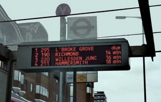
Electronic bus information.
But I don't really expect Rapid KL / DBKL to do so. There are better ways to spend the money, better ways to disseminate the information, and the very high possibility that it will ROSAK within a month. But it would be nice to have something like that, someday!
But how about equipping all buses with GPS and transponders? Have bus stops have unique IDs and let commuters check the journey information from the internet / SMS / telephone? A GPS don't cost that much, and Rapid KL probably needs to develop a system to monitor bus positions anyway, no?
Sooner or later, we can then install those electronic signs. But not so soon la.
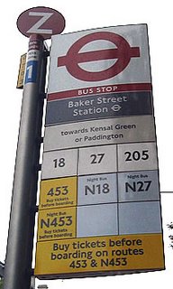
Bloody intuitive. Top to bottom - "Z" bus stop Z at Baker Street Station. Red sign for London Buses. "1" for London Zone 1. "Towards Kensal Green..." mean buses from here go to. Numbers indicating bus routes that stop here. Yellow for purchase tickets before boarding. N-prefixes and blue for Night Buses.
A very low tech solution, but incredibly useful is by providing a "you are here now, and the buses passing here will go to the following places, and will expect to arrive at those places in __ minutes" information panel.

Really useful information. Red paved lane is bus stop.
In London, these panels are fixed on bus stop poles, next to shelters. Commuters just need to refer to the spider map inside the shelter or to this information panel to check bus information.
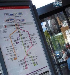
Not the cheap photostat A4 variety - note the colour coded bus routes showing where the journey takes you and where buses meet. Also note the information telling you how long it takes to get to the next stops from here. And also Underground connections.
These panels are interesting because they tell only show you the parts of the journey taken by the bus that will be relavant to you i.e. where the buses will be next heading, and how long it will take to reach.
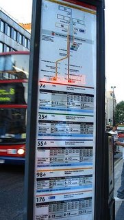
Bus frequencies, according to time and day are also published on the poles
I hope Rapid KL and the other Local Authorities will consider this when they start filling this up:
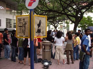
The conteng-menconteng looks better than the cheap looking pole. Am expecting cheap A4 photocopied fax-quality variety (hope I'm wrong about this).
(photo by f-code)
Given that, commuters would still like to know when they can catch their buses.
I think most important of all, bus operators need to publish and guarantee the frequency of the service. We already expect buses to not arrive on time, because of circumstances beyond their control, such as traffic conditions. But still, most people ought to expect a bus to arrive every 5-15 minutes, in spite of traffic, no?
One way to help us know when the bus is arriving is to put up electronic screens:
Electronic bus information.
But I don't really expect Rapid KL / DBKL to do so. There are better ways to spend the money, better ways to disseminate the information, and the very high possibility that it will ROSAK within a month. But it would be nice to have something like that, someday!
But how about equipping all buses with GPS and transponders? Have bus stops have unique IDs and let commuters check the journey information from the internet / SMS / telephone? A GPS don't cost that much, and Rapid KL probably needs to develop a system to monitor bus positions anyway, no?
Sooner or later, we can then install those electronic signs. But not so soon la.

Bloody intuitive. Top to bottom - "Z" bus stop Z at Baker Street Station. Red sign for London Buses. "1" for London Zone 1. "Towards Kensal Green..." mean buses from here go to. Numbers indicating bus routes that stop here. Yellow for purchase tickets before boarding. N-prefixes and blue for Night Buses.
A very low tech solution, but incredibly useful is by providing a "you are here now, and the buses passing here will go to the following places, and will expect to arrive at those places in __ minutes" information panel.
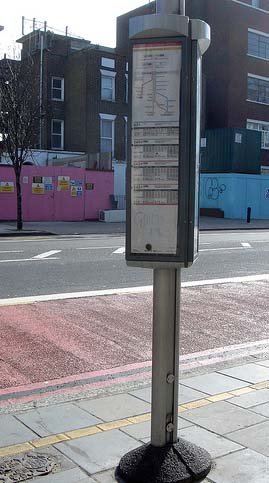
Really useful information. Red paved lane is bus stop.
In London, these panels are fixed on bus stop poles, next to shelters. Commuters just need to refer to the spider map inside the shelter or to this information panel to check bus information.

Not the cheap photostat A4 variety - note the colour coded bus routes showing where the journey takes you and where buses meet. Also note the information telling you how long it takes to get to the next stops from here. And also Underground connections.
These panels are interesting because they tell only show you the parts of the journey taken by the bus that will be relavant to you i.e. where the buses will be next heading, and how long it will take to reach.

Bus frequencies, according to time and day are also published on the poles
I hope Rapid KL and the other Local Authorities will consider this when they start filling this up:

The conteng-menconteng looks better than the cheap looking pole. Am expecting cheap A4 photocopied fax-quality variety (hope I'm wrong about this).
(photo by f-code)
posted by commuter at 1:10 AM
![]()


0 Comments:
Post a Comment
<< Home